![](/images/other/stat-length.png)
![Tour Wandern Mont Lozère et Goulet - Sentier de la mare aux renards - Belvezet - Photo](https://media.geolcdn.com/t/1900/400/ext.pjpeg?maxdim=2&url=https%3A%2F%2Fservices.sitytrail.com%2FGeolivesWS%2FDownloadMedia.ashx%3FTrailID%3D111441%26Media%3D7281_2.jpg)
Sentier de la mare aux renards - Belvezet
tracegps
Benutzer
![Länge](/images/other/stat-length.png)
Länge
10,2 km
![Maximale Höhe](https://static1.geolcdn.com/siteimages/upload/files/1508320355ic_sort_altitude_max_24dp.png)
Maximale Höhe
1389 m
![Positive Höhendifferenz](https://static1.geolcdn.com/siteimages/upload/files/1508320355ic_sort_den_pos_24dp.png)
Positive Höhendifferenz
283 m
![Km-Effort](/images/other/stat-length.png)
Km-Effort
14 km
![Min. Höhe](https://static1.geolcdn.com/siteimages/upload/files/1508320355ic_sort_altitude_min_24dp.png)
Min. Höhe
1181 m
![Negative Höhendifferenz](https://static1.geolcdn.com/siteimages/upload/files/1508320355ic_sort_den_neg_24dp.png)
Negative Höhendifferenz
283 m
![Boucle](https://static1.geolcdn.com/siteimages/upload/files/16400158638029165_repeat_loop_refresh_sync_direction_icon.png)
Boucle
Ja
Erstellungsdatum :
2014-12-10 00:00:00.0
Letzte Änderung :
2014-12-10 00:00:00.0
![Wandern](https://static1.geolcdn.com/sitytour/trail-icons/101.png)
2h40
Schwierigkeit : Medium
![Scannen Sie diesen QR-Code, um die Tour in der SityTrail-Anwendung zu öffnen](https://capi.geolives.com/qq0zvz2zws4bq2lad0pu/sitytour/trails/111441/qr.png?size=200)
Kostenlosegpshiking-Anwendung
Über SityTrail
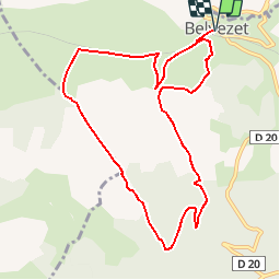
Tour Wandern von 10,2 km verfügbar auf Okzitanien, Lozère, Mont Lozère et Goulet. Diese Tour wird von tracegps vorgeschlagen.
Beschreibung
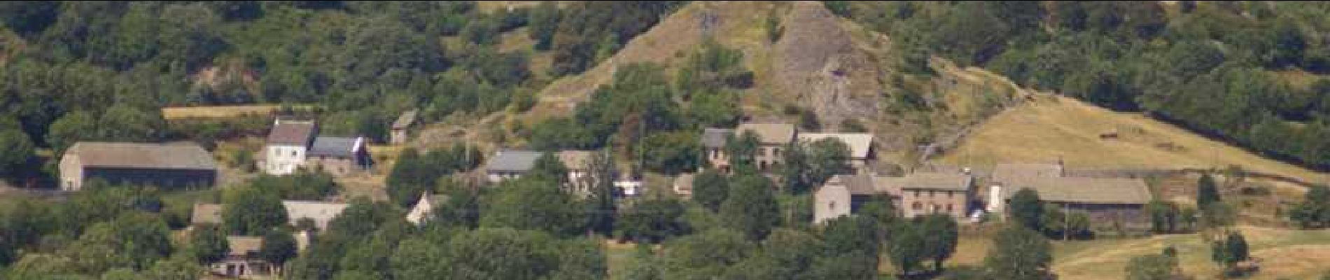
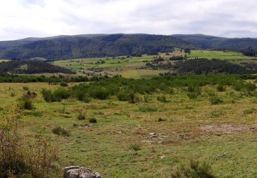
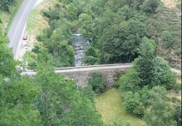
Circuit proposé par la Communauté de Communes du Goulet – Mont Lozère. Départ de Belvezet. Retrouvez le circuit sur le site de la Communauté de Communes. Ce circuit a été numérisé par les randonneurs du CODEPEM. Merci à Jean-Marie.
Ort
Land:
France
Region :
Okzitanien
Abteilung/Provinz :
Lozère
Kommune :
Mont Lozère et Goulet
Standort:
Unknown
Gehen Sie:(Dec)
Gehen Sie:(UTM)
559170 ; 4934730 (31T) N.
Kommentare
Touren in der Umgebung
![Wandern Wandern](https://static1.geolcdn.com/sitytour/trail-icons/101.png)
GR_70_AG_07_Mont-Lozere-Goulet_Cubieres_20140921
Wandern
Sehr schwierig
Mont Lozère et Goulet,
Okzitanien,
Lozère,
France
![](/images/other/stat-length.png)
19,8 km | 30 km-effort
6h 12min
![](https://static1.geolcdn.com/siteimages/upload/files/16400158638029165_repeat_loop_refresh_sync_direction_icon.png)
Nein
![Tour Wandern Allenc - château de la tournelle - Photo](https://media.geolcdn.com/t/375/260/ext.jpg?maxdim=2&url=https%3A%2F%2Fservices.sitytrail.com%2FGeolivesWS%2FDownloadMedia.ashx%3FTrailID%3D207412%26Media%3Dfix__20130724154853.jpg)
![Wandern Wandern](https://static1.geolcdn.com/sitytour/trail-icons/101.png)
château de la tournelle
Wandern
Medium
Allenc,
Okzitanien,
Lozère,
France
![](/images/other/stat-length.png)
12,3 km | 17,9 km-effort
3h 42min
![](https://static1.geolcdn.com/siteimages/upload/files/16400158638029165_repeat_loop_refresh_sync_direction_icon.png)
Nein
![Tour Wandern Mont Lozère et Goulet - Stevenson - Photo](https://media.geolcdn.com/t/375/260/ext.jpg?maxdim=2&url=https%3A%2F%2Fstatic1.geolcdn.com%2Fsiteimages%2Fupload%2Ffiles%2F1553511878bg_sport_marche.png)
![Wandern Wandern](https://static1.geolcdn.com/sitytour/trail-icons/101.png)
Stevenson
Wandern
Sehr schwierig
Mont Lozère et Goulet,
Okzitanien,
Lozère,
France
![](/images/other/stat-length.png)
28 km | 39 km-effort
7h 27min
![](https://static1.geolcdn.com/siteimages/upload/files/16400158638029165_repeat_loop_refresh_sync_direction_icon.png)
Nein
![Tour Elektrofahrrad Allenc - Larzalier mas de la barque - Photo](https://media.geolcdn.com/t/375/260/ext.jpg?maxdim=2&url=https%3A%2F%2Fstatic1.geolcdn.com%2Fsiteimages%2Fupload%2Ffiles%2F1524743154velo.jpg)
![Elektrofahrrad Elektrofahrrad](https://static1.geolcdn.com/sitytour/trail-icons/205.png)
Larzalier mas de la barque
Elektrofahrrad
Einfach
Allenc,
Okzitanien,
Lozère,
France
![](/images/other/stat-length.png)
53 km | 73 km-effort
6min
![](https://static1.geolcdn.com/siteimages/upload/files/16400158638029165_repeat_loop_refresh_sync_direction_icon.png)
Nein
![Tour Reiten Allenc - Boucle Allenc de Gérard Baras - Photo](https://media.geolcdn.com/t/375/260/ext.jpg?maxdim=2&url=https%3A%2F%2Fstatic1.geolcdn.com%2Fsiteimages%2Fupload%2Ffiles%2F1524743154cheval.jpg)
![Reiten Reiten](https://static1.geolcdn.com/sitytour/trail-icons/301.png)
Boucle Allenc de Gérard Baras
Reiten
Schwierig
Allenc,
Okzitanien,
Lozère,
France
![](/images/other/stat-length.png)
34 km | 42 km-effort
5h 18min
![](https://static1.geolcdn.com/siteimages/upload/files/16400158638029165_repeat_loop_refresh_sync_direction_icon.png)
Ja
![Tour Wandern Mont Lozère et Goulet - Stevenson 7 - Photo](https://media.geolcdn.com/t/375/260/ext.jpg?maxdim=2&url=https%3A%2F%2Fstatic1.geolcdn.com%2Fsiteimages%2Fupload%2Ffiles%2F1553511878bg_sport_marche.png)
![Wandern Wandern](https://static1.geolcdn.com/sitytour/trail-icons/101.png)
Stevenson 7
Wandern
Sehr leicht
Mont Lozère et Goulet,
Okzitanien,
Lozère,
France
![](/images/other/stat-length.png)
25 km | 35 km-effort
10h 34min
![](https://static1.geolcdn.com/siteimages/upload/files/16400158638029165_repeat_loop_refresh_sync_direction_icon.png)
Nein
![Tour Wandern Saint-Frézal-d'Albuges - Allier j1 - Photo](https://media.geolcdn.com/t/375/260/ext.jpg?maxdim=2&url=https%3A%2F%2Fstatic1.geolcdn.com%2Fsiteimages%2Fupload%2Ffiles%2F1553511878bg_sport_marche.png)
![Wandern Wandern](https://static1.geolcdn.com/sitytour/trail-icons/101.png)
Allier j1
Wandern
Sehr schwierig
Saint-Frézal-d'Albuges,
Okzitanien,
Lozère,
France
![](/images/other/stat-length.png)
16,5 km | 21 km-effort
4h 29min
![](https://static1.geolcdn.com/siteimages/upload/files/16400158638029165_repeat_loop_refresh_sync_direction_icon.png)
Nein
![Tour Schneeschuhwandern Saint-Frézal-d'Albuges - Le Moure de Gardille - Photo](https://media.geolcdn.com/t/375/260/ext.jpg?maxdim=2&url=https%3A%2F%2Fstatic1.geolcdn.com%2Fsiteimages%2Fupload%2Ffiles%2F1524743153raquette.jpg)
![Schneeschuhwandern Schneeschuhwandern](https://static1.geolcdn.com/sitytour/trail-icons/504.png)
Le Moure de Gardille
Schneeschuhwandern
Sehr leicht
Saint-Frézal-d'Albuges,
Okzitanien,
Lozère,
France
![](/images/other/stat-length.png)
10,2 km | 14,8 km-effort
4h 6min
![](https://static1.geolcdn.com/siteimages/upload/files/16400158638029165_repeat_loop_refresh_sync_direction_icon.png)
Ja
![Tour Reiten Mont Lozère et Goulet - 10.RaccordLeGoulet - Photo](https://media.geolcdn.com/t/375/260/ext.jpg?maxdim=2&url=https%3A%2F%2Fstatic1.geolcdn.com%2Fsiteimages%2Fupload%2Ffiles%2F1524743154cheval.jpg)
![Reiten Reiten](https://static1.geolcdn.com/sitytour/trail-icons/301.png)
10.RaccordLeGoulet
Reiten
Sehr leicht
Mont Lozère et Goulet,
Okzitanien,
Lozère,
France
![](/images/other/stat-length.png)
11,7 km | 14,2 km-effort
Unbekannt
![](https://static1.geolcdn.com/siteimages/upload/files/16400158638029165_repeat_loop_refresh_sync_direction_icon.png)
Nein